
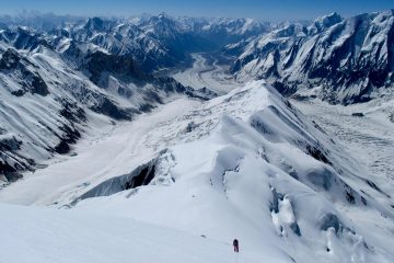
Accessibility to Spantik is relatively easy, yet the peak is still located in a far-flung area. Thanks to the easy access and its location in a safe atmosphere, Spantik has witnessed a rise in the number of expeditions attempting to summit her each year. Getting to the Spantik base camp requires at least 3 days. You would see yourself trailing across a glacial system, and it is always advisalbe to stick with your guide if you want to arrive at the base camp safely. Despite the easy accessibility, the route to the summit of Spantik is reasonably difficult. You have to take the northwest face, also called the Golden Pillar, in order to get a toehold. The good news is that out of all the expeditions to Spantik so far, 80 percent have summited it with success. However, your success relies heavily on your skills, fitness, acclimatization, weather condition and your propensity to go the extra mile.
We have 35 days itinerary for Spantik Peak that starts with your arrival in Islamabad. Adventure trips Advisor will ensure that your travel and expedition is enjoyable, fun, full of adventure and most of all, a delightful experience. We offer you total solution, so our professionals will take care of every facet of expedition, such as your logistics, accommodation, food, travel and everything in between. Even though Spantik Peak is situated in Nagar Valley, yet the route to climb this beautiful and spectacular peak is from the Baltistan side. After your briefing at the Ministry of Tourism in Islamabad, we will arrange your flight to Skardu. You will then trek across the Chogolungma glacier before getting to the Spantik Peak base camp. The route to the 7027 meters Spantik Peak starts in in the Arandu region of Baltistan, also known as little Tibet. Want to join our next expedition to Spantik? Contact us now for details I’s climbing period starts in June and ends in August.
| country | Pakistan |
| Altitude | 7,027m | 23.054ft. |
| Distance-Walk | 5-8 hour |
| Nature | Hotel + Guest House + Camping |
| Duration | 35 days |
| Grade | dificult |
| Group size | 4-10 People |
| Season | Summer |
| Days | Destinations |
| Days 1 | Islamabad Deprature |
| Days 2 | Islamabad – Welcome reception (briefing) at Alpine Club of Pakistan. |
| Days 3 | Skardu/ChilasFly to Skardu at 0930 hrs. Upon arrival transfer to hotel for overnight. Sightseeing around Skardu. The 55 minutes flight to Skardu is a unique experience flying between the towering icy peaks of the mighty Himalayan and rugged Karakorum ranges with extra-ordinary and unforgettable aerial views of clusters of mountains, and Glaciers. While flying don’t miss the most spectacular views of Nanga Parbat (8124m) and K2 (8611m) from the cockpit. These two mountains tower over all the others. In case of cancellation of flight (12 – 14 hrs) drive by coach to Chilas (480km) on Karakorum Highway. Overnight at hotel. Driving on the KKH is exciting. The KKH is one of the most spectacular roads and the world’s highest metalled border crossing. It connects Pakistan and China stretching over a distance of 1300 km between Islamabad and Kashgar winding through three mountain ranges and following the ancient Silk route along the Indus valley to the Chinese border at Khunjerab pass |
| Days 4 | Chilas/Skardu1. Day free at Skardu.2. If you are driving, complete road journey (07 – 08 hrs) to Skardu (275 km). Enroute stop on a viewpoint near Thalichi to take a view of Nanga Parbat. Austrian Climber, Hermann Bhul climbed this face on July 3, 1953. It is a nice spot to take pictures in combination with Indus and the Nanga Parbat in the background. We will cross the Alam Bridge over Gilgit River to continue our journey towards Skardu and drive on Skardu Road along the Right Bank of the Indus River. En-route we will have the close views of Nanga Parbat, confluence of the Indus and Gilgit Rivers, junctions of the three mightiest ranges of Himalayas, Karakoram and Hindu Kush as well as the rapids and falls of Indus River. The town of Skardu (2234m) is situated along the south side of the Indus River. It is a broad Valley about 40km long and 10km wide. Skardu is now the administrative center of the District and also transportation and commercial center of Baltistan region. |
| Days 5 | Skardu to Arandu is an early start because of the long day journey. The road to Shigar Valley bridges the Indus from Thorego some (10km) east of Skardu. The road then runs through the sand dunes before climbing over a shoulder of mountain from where a majestic view of the entire Shigar Valley can be seen up to the junction of Braldu and Basha Rivers. The road then descends to the Shigar village (32km). From Shigar the jeep trek goes up the West Bank of the river. Enroute at Chu Tron we can see hot springs with separate bathing huts for men and women. The jeep track goes up the valley to the beautiful village of Doko (20km) from where we trek to Arandu the last village at the snout of the wonderful (38km) ChogoLungma Glacier. The trail starts through walnut groves and then goes up and down the hillside with beautiful view of cultivated fields and villages on the other side of the river. It is an easy walk up to Sesko beyond which it becomes stony and slippery due to landslides. After Bulcho the valley opens up and after trekking about (5hrs) from Doko we reach Arandu. Overnight at camp above the village at about 2950 meters. |
| Days 6 | From Arandu to BukhumIt takes about (8 hrs) to reach Bukhum, which is a summer settlement. The trail follows the Basha River up to the snout of the ChogoLungma Glacier. After crossing the glacier follow the northern lateral moraine to Bukhum. Overnight at camp |
| Days 7 | Bukhum to KhurumalIt is (5 – 8 hrs) trekking. Watching the miracle views of the pyramid of Spantik, passing through Manchikera, which is a summer settlement we reach another summer settlement of Khurumal. Overnight at camp |
| Days 8 | Khurumal to BoluchoIt is relatively short stage, which takes (4 –5 hrs). Passing through the summer settlement of Gharincho and a small lake and enjoying the excellent views of Spantik and Laila Peaks we reach Bolucho, which is situated at the base of the Bolucho Glacier. Overnight at camp at about (3,900 meters) on a green ground with water. |
| Days 9-30 | From Bolucho to Base Camp (For acclimatization and climbing 20 days)We will establish three high altitude camps to climb Spantik. Alternating between these camps will help acclimatize the team; this is the key to success. Certain parts of the route between different camps will be equipped with fixed cords for safety and going and coming without any hassles. We will climb about (8km) up to the origin of ChogoLungma Glacier to set up Camp 1 at 4550 meters. Camp 2 and Camp 3 are installed at mini summits of southeastern ridge with a view of 360º. The route from Camp 1 up to (5100m) altitude consists of many ice pitches with many crevasses requiring 8 ropes fix line. Beyond this point up to camp 2, no rope is required. The climbing from Camp 2 at (5500m) to Camp 3 at (6550m) comprises ice with some dangerous steep crevasses requiring 6 ropes to fix on this section. From Camp 3 to summit two ropes will be enough as safety rope |
| Days 31 | Return to Bolucho. Overnight at camp. |
| Days 32 | Return to ChogoBrangsa. Overnight at camp. |
| Days 33 | Return to Arandu. Overnight at camp.Day 34Return to Skardu. Drive by jeep to Skardu. Overnight at hotel. |
| Days 34 | Islamabad/Chilas 1. Fly to Islamabad at 1120 hrs (subject to weather conditions). Overnight at hotel. 2. In case of flight cancellation drive to Chilas. Overnight at hotel. |
| Days 35 | Islamabad. |